LEARN THE LAKE SERIES - HWY 17 BRIDGE IN MUSTANG
Locations #1 thru #7WANT TO SEE WHAT IT LOOKS LIKE NOW? – CLICK FOR CURRENT GOOGLE AERIAL PHOTO AND BUSINESS INFORMATION
Pre-inundation photo of Mustang Creek
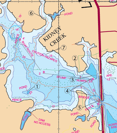
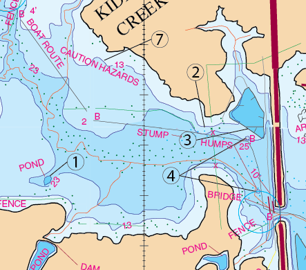
Location #1, #2, #3, #4, & #7The area west of the Hwy 17 bridge
Location: #1
Pond Dam.
Timing: All seasons.
What to do: Use Jigs, Cotton Candy Colored French Frys, Carolina or Texas rigs with Lizard or Worm.
Location: #2 & #7
This is a very, very productive night fishing pattern. Focus your efforts at location #2. You can begin fishing at a spot located on the north shore where the power line goes over the lake. Begin on that north side of Mustang and fish this bank from here and go west to location #7. You basically can go all the way west to Kidney Creek. The key to this whole technique is this. This area is usually great at midnight and 2:30AM. The significant factor to look for is grass. For this to be good it has to have good grass on it. This area right here will either have great grass on it or it will have that old dead brown grass on it. If it has the dead grass then it is not going to be very productive at all. If it has a good growth of green grass then you can’t beat this bank right here between midnight and 2:30AM. This area will be good for several fish. Many of those will be be very good fish. This can produce some really nice night fishing trips.
Timing: Fish it at night starting in April through August (Midnight to 2:30AM).
What to Do: There are two baits that work well for this area. Throw a black 6″ Hawg craw with powder blue pincers (made by Gene Larew) that is Texas-rigged style. The other bait to use is a 1/2-oz black spinner bait (with a gold blade on it).
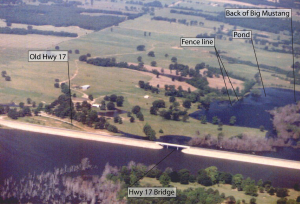
Big Mustang Creek at the Hwy 17 Bridge. Lake level elevation at elevation 388.55′. 14.45′ below normal pool level. View Looking West.
Location: #3
This is a borrow pit where dirt was taken out for construction of the bridge.
Timing: All seasons.
What to do: Use white spinner bait or a red rattle trap.
Location: #4
Two humps just west of the dam.
Timing: May, June.
What to do: Use a fluke or crank bait.
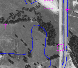
The blue outline in the picture is the approximate location of the lake filled with water. You are looking at the dry lake bed in the picture. The magenta arrow to the left points to the creek channel. The arrow to the right points to the new Hwy17 bridge. The magenta box a the bottom of the photo shows the old Hwy 17 bridge that is now underwater. The box at the top of the photo shows the borrow pit area.
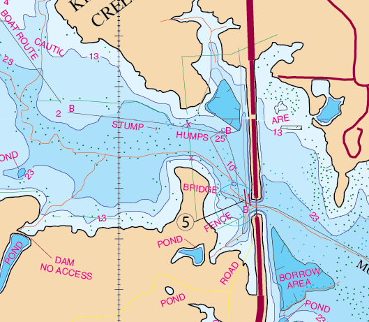
The underwater bridge where old Hwy 17 crosses Mustang Creek.
There are two times during the year that you should concentrate on this area-New Years Day and Labor Day weekend (around September 1st). Believe it or not the first available time is New Years Day. On Labor Day prepare yourself to have a lot of company here. This is a popular place at this time of year. Nine pound bass and up have been caught here even at this time of year.
Timing: New Years Day and Labor Day weekend (around September 1st).
What to Do: Labor Day, you can position your boat at the buoy marker near location #5. You will want to throw a black and blue jig up on that concrete bridge apron. You will want to bounce that jig off of that concrete apron and allow it to fall down into the water. You can also jig around where the main creek splits. You’re not limited to this particular spot, so you can fish both sides of this bridge. The same thing goes for New Years Day.
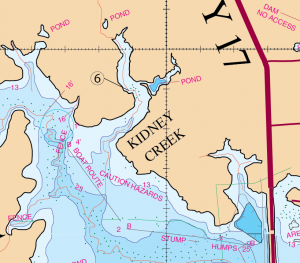
Kidney Creek
During this time you will notice there are quite a few boats that fish on both sides of this bridge (noticeably, an understatement). The fish will be positioning themselves for their fall feeding patterns. They will travel to this area and they will hang around this bridge. They will stage in this area as they gorge up on shad. Position your boat right here on the creek and fish the bridge opening. Also fish both sides of the bridge. Stay close to the bridge and fish the corners of the concrete skirting. This will be where the bridge touches the water.
Timing: Labor Day weekend and also during the spawn
What to Do: What you want to use is Rattle-traps (chrome with a blue back), spoons, Tail-kickers, and also a Carolina rig can be used effectively as well.
Spawn Timing: Go during the magic temperatures-The spawn occurs at 64 degree water temperature. This is a great spawning creek. Fish the spawn all the way back in the back of Kidney Creek. This creek gets a lot of pressure.
What to Do: Look for bed fish and once you locate them use a bubble gum colored lizard (Texas Rigged)
Video of the trees three years after the lake filled.
VIDEO CLIP
This is a video clip taken from a film made of Lake Fork back in 1988. This view is looking northeast. The road in the video is Hwy 17 and it shows the bridge. I like the fact that the fence lines can be clearly seen. The video was taken approximately 3 years after the lake fully filled with water. It’s beneficial since the video wast taken back when the trees were all still sticking up above water.
Video provided by Robert E and Michele Wood with S-W Group Inc. – Photo Fishing System Company. COPYRIGHT 1988 ALL RIGHTS RESERVED.
GPS COORDINATES*
1. N32D 51.600’ & W95D 38.600’, N32D 51′ 36.000″ & W95D 38′ 36.000″ POND
2. N32D 51.550’ & W95D 37.840’, N32D 51′ 33.000″ & W95D 37′ 50.400″ POINT
3. N32D 51.546’ & W95D 37.774’ HUMP, N32D 51′ 32.776″ & W95D 37′ 46.468″ BORROW PIT
4. N32D 51.514’ & W95D 37.756’ HUMP, N32D 51′ 30.867″ & W95D 37′ 45.385″ HUMP
4a.N32D 51.408’ & W95D 37.732’ HUMP, N32D 51′ 24.508″ & W95D 37′ 43.895″ HUMP
5. N32D 51.372’ & W95D 37.700’ BRIDGE, N32D 51′ 22.320″ & W95D 37′ 42.000″ BRIDGE
6. N32D 51.900’ & W95D 38.100’, N32D 51′ 54.000″ & W95D 38′ 6.000″ CREEK BEND
7. N32D 51.660’ & W95D 38.085’, . N32D 51′ 39.600″ & W95D 38′ 5.100″
*Note: These are approximate locations and have not been field checked. The Datum used was NAD 27. These coordinates have been taken directly from our map so they are not entirely accurate. We plan to update these in the future with actual field measurements and we will indicate that when we do. If you have any coordinates that you feel are more accurate and would like to share them, then we would love to hear from you. Also you will notice the above coordinates are in two different formats. The first set is for the older units that showed degrees, minutes.decimal, and the second set is for the newer units that show degrees, minutes and seconds.decimal.