LEARN THE LAKE SERIES

MUSTANG CREEK - WEST END

WANT TO SEE WHAT IT LOOKS LIKE NOW? – CLICK FOR CURRENT GOOGLE AERIAL PHOTO AND BUSINESS INFORMATION

RELATED VIDEO CLIPS

https://youtu.be/rdu6O1meBNs
In episode 9 Bob Robert’s plan is to pre-fish the back of Big and Little Mustang Creek. Bob believes that most of the tournament members will fish in the back of Little Caney. Bob takes a chance by fishing a cove that should have less anglers in it and may contain some grass. This video series’s goal is to capture the thought process of a successful angler’s mind when fishing Lake Fork. Bob has very generously offered to allow us to cover his trek through this 2019’s “Hard Core” tournament category from January to the end of this year’s spawn season. Bob talks about locations 1 through 5.

https://youtu.be/UeZZgQhpTGI
In episode 10 Bob took a chance by fishing a cove that should have had less anglers in it. He hoped that it would contain some grass. Bob runs into some serious weather drops. This episode covers the results of the tournament.

West Point in Mustang Creek

Location #1, #2, #2b, #3

Comment
There is no grass in the back of Big Mustang Creek – Bob Roberts 2/17/19
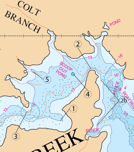
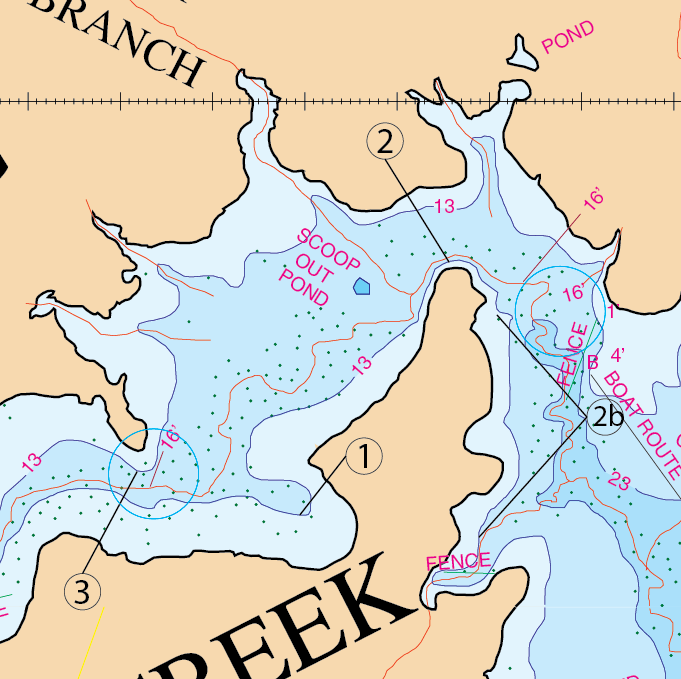
Location: #1
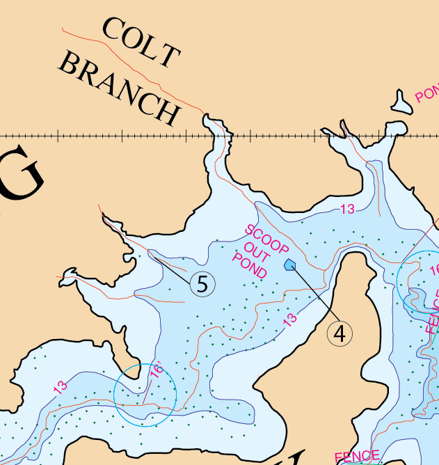
South Pocket West of West Point – A great place in Big Mustang is west and south of the previously mentioned long point location #2.  This area here contains a pocket that has a little gut that runs into it. Notice where the creek bends, these fish will move up here right through that gut and hold there. This pocket has a tree line running up the middle of it to about 2/3 of the way to the back of it.

Timing: March pre-spawn and spawn

What to Do:  Fish every bit of this water. Be aware that that the fish will move in to spawn and they will follow this tree line. Fish this tree line with a jig, Carolina rigged lizard or a Texas rigged lizard. The back 1/3 of the pocket is where this tree line stops. You will also want to notice the vegetation growing around the shore-line. If you go back there throw the watermelon super fluke. If this cove is in a pre-spawn mode throw the suspended rogue. If the bass are bedding, catch them with the bubblegum 6″ Gene Larew Hog Crawl.

Location: #2 & #2b

You don’t ever want to fish Mustang with out fishing this point. This would be the location where the creek wraps around the point due west of Kidney Creek. The creek here just hugs this bank.  Everybody fishes here.  You can catch an eight and half pound fish in here in late March when it’s got the good grass on it.  It’s good along this point and back to the east and south.  You can fish it with a variety of lures. Know this, you are fishing a major creek bending around a long point with trees and vegetation located all around it. Add to this bait fish and you will catch fish feeding and schooling here in the early fall. This area will be an area that holds fish through much of the year. Let the season pattern tell you exactly how and where to fish this.  This is an outstanding structure all around this long land point.  Now don’t overlook the area east and south of location #2 where it goes south all the way into that small cove area where the fence is.  All up and down that bank is a good spawn area that produces some good fish there.  This area is a good area to catch 8-½ lb. Fish.

Timing: You can start fishing this in Late March.

What to Do:  Use top waters with propellers, rattle traps and slow falling super flukes in this area. Throw spinner baits in here and also throw the Hawg-Craw in there. Pre-spawn is 52 to 60 degrees water temperature-throw red rattle traps, chartreuse/white spinner baits, suspended rogues, and black/blue jigs. During spawn (at 64 degrees water temperature) your best shot in here is a lizard-either Texas or Carolina rigged.

Location: #3

Long extended point.

Timing: March pre-spawn and spawn.

What to Do:  Fish with Rattle traps and white spinner baits.

The Three ditches near Colt Branch

Location #4 & #5

Location: #4

Location #4 is a small scooped out pond.

Location: #5
COMMENT: “These three small creeks have silted in quite a bit and are only about 6″ deeper than the rest of the area in here” Bob Roberts 1/24/2019

SILT KILLED THIS SPOT – Location #5 is the middle one of three ditches that used to have a lot more depth to them than they do now.   In in the old days, in a pre-spawn situation every one of these ditches would produce fish at that time.  The fish would feed all along the 13 foot contour line that runs from this cove to the Colt Branch Cove. In a Pre-spawn situation you would align your boat with each of the three ditches.  You would throw a super fluke watermelon w/ chartreuse on the tail in a pre-spawn situation. That time period was around March when the water temperature turns between 52 and 60 degrees.  They are now reported to be only 6″ deeper than the rest of the area.

Timing: (No longer a valid location).

What to Do:  (No longer a valid location).

Far West End of Mustang Creek

This is a video clip taken from a film made of Lake Fork back in 1988. This view is looking northeast. Area shows Colt Branch, The West Point in Mustang Creek, and the south pocket West of that point. The video was taken approximately 3 years after the lake fully filled with water.

Video provided by Robert E and Michele Wood with S-W Group Inc. – Photo Fishing System Company. COPYRIGHT 1988 ALL RIGHTS RESERVED.

GPS COORDINATES*

1. N32d 51.600’ & W95d 38.600’, N32d 51′ 36.000″ & W95d 38′ 36.000″ GUT
2. N32d 51.855’ & W95d 38.435’, N32d 51′ 51.300″  & W95d 38′ 26.100″ QUICK DROP OFF
2b. N32d 51.825’ & W95d 38.391’, N32d 51′ 51′ 49.500″ & W95d 38′ 23.46″ SPAWN BANK
& N32d 51.588’ & W95d 38.411’, N32d 51′ 35.28″ & W95d 38′ 24.660″ SPAWN BANK
3. N32d 51.661’ & W95d 38.774’,N32d 51′ 39.66″ & W95d 38′ 46.44″ POINT
4. N32d 51.829’ & W95d 38.540’, N32d 51′ 49.74″ & W95d 38′ 32.400″ SCOOP OUT POND
5. N32d 51.790’ & W95d 38.780’, N32d 51′ 47.400″ & W95d 46.800’ CREEK

*Note: These are approximate locations and have not been field checked. The Datum used was NAD 27. These coordinates have been taken directly from our map so they are not entirely accurate. We plan to update these in the future with actual field measurements and we will indicate that when we do. If you have any coordinates that you feel are more accurate and would like to share them, then we would love to hear from you. Also you will notice the above coordinates are in two different formats. The first set is for the older units that showed degrees, minutes.decimal, and the second set is for the newer units that show degrees, minutes and seconds.decimal.