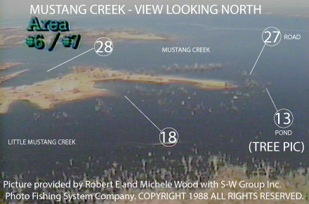
MUSTANG CREEK - SOUTH ENTRANCE
PICTURE AT NORMAL POOL LEVEL
WANT TO SEE WHAT IT LOOKS LIKE NOW? – CLICK FOR CURRENT GOOGLE AERIAL PHOTO AND BUSINESS INFORMATION
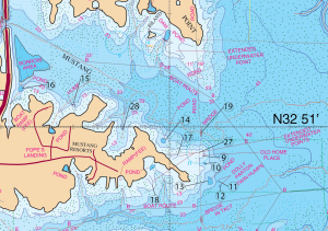
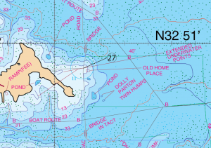
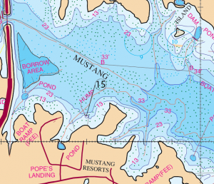
Locations: #9, #10, #11, #12, #13, #14, #15, #16, #17, #18, #19, #27, & #28.
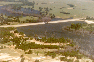
The first picture shown below the view is looking southwest at the old home place. This is at elevation 388.55′. This is 14.45′ below normal pool elevation. This is a good little area. There are several small ponds, a road bed that cuts across, a bridge (in tact to the south) and a couple of small fishing areas to the south that some of the guides refer to as Dolly Parton’s twin humps. I’m not sure how that name came about. This is just what it’s been called in the past.
Timing: Year round.
What to do: Flukes, Carolina or Texas rigged lizards or worms, Watermelon Candy Red Brush Hogs or Cotton Candy colored French Frys.
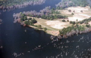
This picture is a view of the the same location looking North west.
This picture is at that same location View Looking West at the south shore of Mustang Creek. Hwy 17 is shown in the background.
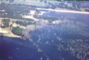
Old home place at the mouth of Big Mustang Creek
This is a hump in the mouth of Big Mustang on the point and on the southern shoreline. This would be at the location where these two roads intersect. That’s where the pre-spawn suspended rogue bite is. Grass normally grows here in March. Plan to be there then.
Timing: Pre-Spawn – water temperature between 55 and 60 degrees. This will be the during the first couple of weeks in March.
What to Do: Use a jerk bait here (a suspended rogue-gold sides, black back and orange belly-the big one the 5 1/2″) when the water temperature is between 55 and 60 degrees. Throw this bait out in the grass and work the bait where it is suspended. If this area has grass the fish will come out of the grass and hit the bait. That’s a good pre-spawn fishing pattern.
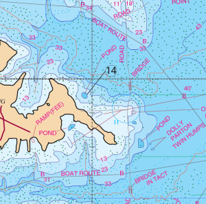
Location: #14
The Pond West of the Old Home Place #14
During the McDonald’s (Now called the Big Splash) tournament this pond produces some nice fish. This is the pond that is located west of the old home place in big Mustang. Fish this pond in the first part of September.
Timing: September, and also around the same time as the McDonald’s tournament.
What to Do: Fish the Dam with a Texas-Rigged tequila sunrise worm or a Carolina Rig. Fish the dam on this pond.
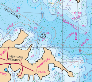
Location: #28
This is the cove on the south bank of Mustang. It is east of Pope’s Landing and west of the pond we just talked about previously. The significant thing about this cove is the fact that the creek gets so close to the south and north point. Protected from the wind, the water will warm up faster. You have a creek that will feed into it and you have a sharp drop off at the south point. This cove contains a lot of structure values that tell these fish to come in there and get ready to spawn.
Timing: Mid-Morning – last two weeks of February. The water temperature should be 55-60 degrees.
What to Do: Throw a chartreuse/white gold blade spinner bait. The fish will be good up to 7-½ lb.
This spot is a summer time deep-water hole-July through August. It is an isolated large brush pile.
Timing: July through August.
What to Do: It’s summer time during the middle of the day. The fish will gather deep around this isolated brush pile. If you find fish with your electronics in 22 to 28 feet of water chink a Carolina Rig, a tail kicker or a spoon here. Fish this in the hot summer months, July and August.
Mustang Creek and Hwy 17. Lake Elevation 388.55′. 14.45′ Below normal pool level. View Looking Northwest.
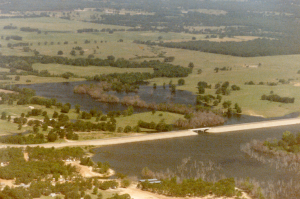
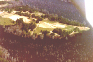
This picture is looking due south at Pope’s Landing. Lake level is at Elevation 388.55′. 14.45′ Below normal pool level.
GPS COORDINATES*
9. N32D 50.901’ & W95D 36.856’, N32D 50′ 54.060″ & W95D 36′ 51.36″ HOME PLACE
10. N32D 50.872’ & W95D 36.854’, N32D 50′ 52.320″ & W95D 36′ 51.240″ POND
11. N32D 50.809’ & W95D 36.799’, N32D 50′ 48.540″’ & W95D 36′ 47.940″ DOLLY P HUMP
12. N32D 50.794’ & W95D 36.789’, N32D 50′ 47.640″ & W95D 36′ 47.340″ DOLLY P HUMP
13. N32D 50.809’ & W95D 36.830’, N32D 50′ 48.540″ & W95D 36′ 49.800″ POND
14. N32D 50.952’ & W95D 37.025’, N32D 50′ 57.120″ & W95D 37′ 1.500″ POND
15. N32D 51.075’ & W95D 37.401’, N32D 51′ 4.500″ & W95D 37′ 24.060″ HUMP
16. N32D 51.138’ & W95D 37.616, N32D 51′ 8.280″ & W95D 37′ 36.96″ POND
17. N32D 50.899’ & W95D 36.971’, N32D 50′ 53.940″ & W95D 36′ 58.260″ EXTENDED POINT
18. N32D 50.803’ & W95D 37.072’, N32D 50′ 48.180″ & W95D 37′ 4.320″ EXTENDED POINT
19. N32D 50.980’ & W95D 36.868’, N32D 50′ 58.800″ & W95D 36′ 52.080″ BRIDGE
20. N32D 51.670’ & W95D 37.045’, N32D 51′ 40.200″ & W95D 37′ 2.700″ POND DAM
21. N32D 51.210 & W95D 36.870’, N32D 51′ 12.600″ & W95D 36′ 52.200″
22. N32D 51.830’ & W95D 37.290’, N32D 51′ 49.800″ & W95D 37′ 17.400″ SPAWNING AREA
23. N32D 51.798’ & W95D 36.705’, N32D 51′ 47.880″ & W95D 36′ 42.300″ END OF HORSESHOE RIDGE
24. N32D 51.608’ & W95D 36.908’, N32D 51′ 36.480″ & W95D 36′ 54.480″ ROAD BED
25. N32D 51.245’ & W95D 37.000’, N32D 51′ 14.700″ & W95D 37′ 0.000″ FLAT
26. N32D 51.184’ & W95D 36.890’, N32D 51′ 11.040″ & W95D 36′ 53.400″ ROAD BED
27. N32D 50.909’ & W95D 36.878’, N32D 50′ 54.540″ & W95D 36′ 52.680″ ROAD BED
28. N32D 50.990’ & W95D 37.195’, N32D 50′ 59.400″ & W95D 37′ 11.700″
*Note: These are approximate locations and have not been field checked. The Datum used was NAD 27. These coordinates have been taken directly from our map so they are not entirely accurate. We plan to update these in the future with actual field measurements and we will indicate that when we do. If you have any coordinates that you feel are more accurate and would like to share them, then we would love to hear from you. Also you will notice the above coordinates are in two different formats. The first set is for the older units that showed degrees, minutes.decimal, and the second set is for the newer units that show degrees, minutes and seconds.decimal.