Mustang Creek - North Entrance

LOCATIONS: #5, #6, #7, #8, #21, #25, & #26

WANT TO SEE WHAT IT LOOKS LIKE NOW? – CLICK FOR CURRENT GOOGLE AERIAL PHOTO AND BUSINESS INFORMATION

APPLICABLE VIDEOS

Episode27 Part 1
https://youtu.be/Ij2G6thlpmg
Pro-fishing guide Mike McFarland explains in detail the ins and outs of fishing shell beds on Lake Fork. Part 2 Mike shows an actual location and talks about how he fishes it.

Episode27 Part 2
https://youtu.be/Mx23MwjRja0
Pro-fishing guide Mike McFarland explains in detail the ins and outs of fishing shell beds on Lake Fork. In episode27 Part 2 Mike shows an actual location in Big Mustang and talks about how he fishes it.


Note that these locations #5, #6, #7, #8, #21, #25, & #26 all contain significant shell beds.

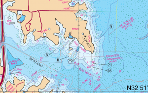
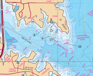
Location #6, #8, & #25,
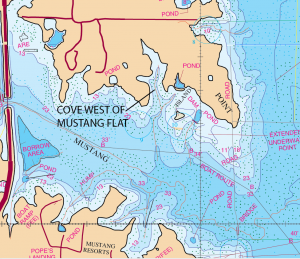
Big Mustang Flat-
“An Important Flat”

Timing: Year Round Use.

Location: #6, #8, & #25.
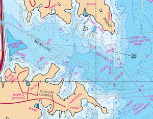
This area is located on the north shore of Big Mustang Creek at the entrance point.  This area (#25) includes a large flat, an island, a roadbed (#26), some creek channels (or guts) and several protruding points (#6) & (#8). Most of these locations in here contain some serious shell beds in here.  I would suggest that you review the Mike McFaland video before fishing this (linked above near the title of this article). This location requires that you have some very definite criteria s before fishing shell beds works in here.  #26 – This area is very similar to “the flat” that we discussed in detail earlier at the Electric Ladyland site. This is a rather large flat which posses numerous viable structures. These structures are the very reasons that allow Big Mustang Creek to be fished effectively year round.

Description:  The table top portion of this spot #25

Essentially the top of this structure acts like one big tabletop covered with water especially when it has some very good grass. This tabletop has two guts that lead directly to the main body of this pond/cove. This spot has four body points and an open waterside hump (hump to the Far East-location #26). These spots provide for some great feeding areas for bass. Hump #26 is just on the east side of the old Hwy 17 road.  This area does not provide much wind protection. However, often there is a wind pattern that pushes the bait fish into the cuts and up on the flat. Bass will often travel up these guts and the roadbed. Sometimes they will get up on the flat and flush the bait fish that hold in patterns around these little humps, the four points, the roadbed and the open water hump. When the bait fish group in this area they are prime targets for an ambush by big fish here.  It is no surprise that more often than not you will see a boat fishing this location #26.  This area is one of those year round productive fishing places.

Timing:  Year round.  Let the water temperature tell you what to do. Just fish this area with a lure that you have some degree of confidence in.

What to do:  Below is a table which you can usually go by.  A rule of thumb if you wish.

Water Temperature Lure Type

If the water temperature is below 52 degrees use Jigs or spoons

If the water temperature is 52 Degrees use a Red Rattle Trap

If the water temperature is 55 Degrees use Chartreuse Spinner Baits

If the water temperature is 60 Degrees Jerk Baits, Super Flukes, Lizards

If the water temperature is 64 Degrees and you’re on Bed Fish – use hot pink, bubblegum lizards Texas or Carolina rigged lizards or use a white lizard dipped in a yellow Dip and Glo to help you see better when the fish actually takes the bait.

If the water temperature is 70-72 Degrees use Crank or Top Water Baits

If the water temperature is 80 Degrees plus use Carolina Rigs or Top Water Baits

Very important! When the wind blows into this area. If the wind is still blowing into this area the smart move is to throw moving baits such bass crank baits, rattle traps, spinner baits, or buzz baits. The rule of thumb is to let the water temperature help you select your lure. If the wind is now blowing opposite from what it was for the last three days and you are fishing “slick” water (flat water with no ripple) throw slower moving baits such as worms, Jigs, lizards, super flukes, and top water baits. Use a stop and pause type presentation.

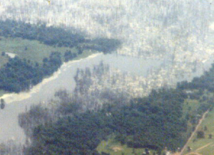
The picture shown below is the mouth of Mustang Creek. Elevation 388.55. 14.45′ below normal pool level. The view is looking northeast.  The protruding green part of this, mid-picture, sticking out from left to right is the location #26 which sits exposed, out of the water.  Notice the amount of available timber before inundation at this spot.  If you look closely you can see the old Hwy 17 road’s path following from left to right in the picture. Here you have deep, main-lake open water, close to this great point next to this very nice flat. These fish migrate out of the deep water and isolate their food in these shallow water areas around this point and the others at locations #8 & #6 and around the flat.


Cove West of Mustang Flat

The Big Cove-West of the Pond-(Big Mustang Flat)

This cove by all laws of nature should be a good spawning cove. Unfortunately it is not. You normally do not find a lot of heavily occupied beds here. A reason that this cove is not a good spawning cove could be the fact that it receives enormous fishing pressure. Fish that spawn here may be doing so in deeper water as a result of that pressure.

What to Do:  Remember; treat this area as you would your typical flat. The lake point on the west side of the cove (location #8) can be identified as a classic point for worm fishing.  You would use deep diving crank baits here as well.  Fish this point during post-spawn, which would be May and June. Note:  normally, fishing the spawn here is not very productive. There are better areas for the spawn than here. You can, for most purposes, fish this area throughout the year. You can fish it early or late but just not the spawn.

Location #26

The Open Water Hump to the Far East-A Big Fish Spot (Big Mustang Flat).  This spot (mentioned previously) is basically a long extended point that drops off into 33’ of water. It has a hump that lies beside the old Hwy 17  roadbed. The roadbed continues north past the hump along the long point and runs all the way inland. The hump itself lies in a heavily treed area on the east side of the road. Actually there are some smaller trees (smaller than the trees that surround the hump) on top of this hump. The top surface area of this hump is a very small area. It’s not very big at all. At one time you could spot this hump by the height of the trees.  The hump was located where the tallest trees were. Note that the road had a clearly defined fence on each side of it. The fence on the east side of the road butted right up against the tree line. Each side of the road had a little bit of slope to it. Fish will school up on this road during the fall season.  This spot will contain larger fish than the points, cove and pond west of here normally. The trees on top of this hump are more like stickups. They do not have much in the way of limbs.  This area also contains some serious shell beds on each side of the submerged road.

Timing: Year round and especially fish this hump in May thru fall.

What to Do: Use a Carolina Rig, Deep Diving Crank Bait or worms.

Note: This hump is a place for the dedicated angler to sit for a long period of time in order to fish for a bigger fish. If you are going to catch a bigger fish (bigger than the fish on the flat) then this location #26 is the spot you would would want to fish in this area.

This is a video clip taken from a film made of Lake Fork back in 1988. This view is directly down on shots #21 & #26. The video was taken approximately 3 years after the lake fully filled with water.  You can easily see the tree line that falls along each side of the old Hwy 17 road bed.  Video provided by Robert E and Michele Wood with S-W Group Inc. – Photo Fishing System Company. COPYRIGHT 1988 ALL RIGHTS RESERVED.


Lake Fork Mustang Creek

North Shore Mustang Creek

This is a video clip taken from a film made of Lake Fork back in 1988. This view is looking north.  The first red arrow in the picture points to Mustang Flat.  The second arrow in the film points to the old road bed that runs from north to south.  The Boot Hill area can be seen in the background and further back the West 515 Bridge can be seen.  The video was taken approximately 3 years after the lake fully filled with water.  Video provided by Robert E and Michele Wood with S-W Group Inc. – Photo Fishing System Company. COPYRIGHT 1988 ALL RIGHTS RESERVED.

GPS COORDINATES*

5. N32D 51.382’ & W95D 36.831’, N32D 51′ 22.92″ & W95D 36′ 49.860″ EXTENDED POINT
6. N32D 51.268’ & W95D 37.080’, N32D 51′ 16.08″ & W95D 37′ 4.800″ EXTENDED POINT
7. N32D 51.307’ & W95D 37.019’, N32D 51′ 18.420″ & W95D 37′ 1.140″ POND DAM
8. N32D 51.318’ & W95D 37.207’, N32D 51′ 19.080″ & W95D 37′ 12.420″ EXTENDED POINT
21. N32D 51.210 & W95D 36.870’, N32D 51′ 12.600″ & W95D 36′ 52.200″ EXTENDED POINT
25. N32D 51.245’ & W95D 37.000’, N32D 51′ 14.700″ & W95D 37′ 0.000″ FLAT
26. N32D 51.184’ & W95D 36.890’, N32D 51′ 11.040″ & W95D 36′ 53.400″ ROAD BED

*Note: These are approximate locations and have not been field checked. The Datum used was NAD 27. These coordinates have been taken directly from our map so they are not entirely accurate. We plan to update these in the future with actual field measurements and we will indicate that when we do. If you have any coordinates that you feel are more accurate and would like to share them, then we would love to hear from you. Also you will notice the above coordinates are in two different formats. The first set is for the older units that showed degrees, minutes.decimal, and the second set is for the newer units that show degrees, minutes and seconds.decimal.