LEARN THE LAKE SERIES - SECRET COVE
Locations #1 thru #11WANT TO SEE WHAT IT LOOKS LIKE NOW? – CLICK FOR CURRENT GOOGLE AERIAL PHOTO AND BUSINESS INFORMATION
Episode 11
https://youtu.be/IpLDKb_teDk
Episode11-Getting ready for Lake Fork bass tournament in Birch Creek with Bob Roberts. Covers location #1.
Comment
Spring Creek has grass – Bob Roberts 2/10/19
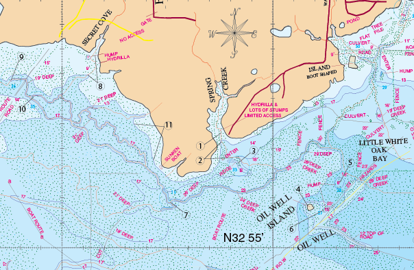
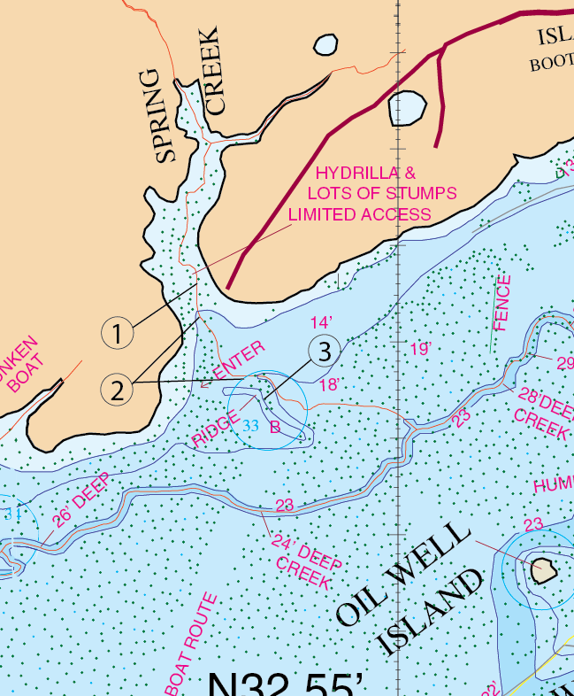
SPRING CREEK
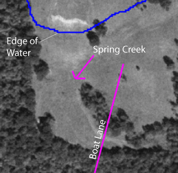
This is also known as Paradise Cove by some. Spring Creek is one of the first creeks that warm up for spawning fish. There is a boat lane that is due west of Boot Island that you can access this cove from the main lake body by. Once you get here you will need to enter in on the west side and make your way back. There are basically two times of the year that we’re aware of that you can have good success here. One, during the spawn, that east bank has seemed to always produce fish(location #1). Two, around labor day out in the mouth (location #2) you will want to to use 6″ tequila sunrise worms to catch these fish in here. It’s good worm fishing in here right at that time. Also there is a ridge that you will want to explore as well in here (location #3). This cove will hardly ever fail you for a decent one fish.
Timing: March, the spawn.
What to do: Use hot pink or bubble gum colored Texas or Carolina rigged lizard or worm.
Timing: Around labor day – September.
What to do: Use 6″ to 7″ tequila sunrise worms because we’re in that September mode.
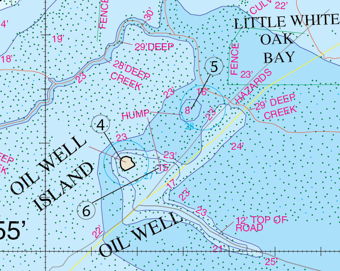
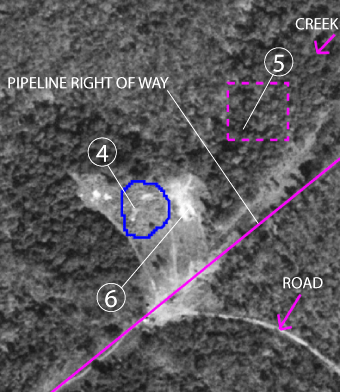
Oil Well Island is one of the better fishing spots on Lake Fork. It is definitely an area worth mentioning. It’s shape and depth does attract fish. As the name suggests it was once the site for an oil well. An underwater point is formed on the left of the island with good deep water that wraps around the hump(location #4). It has a pipeline right of way (shown in yellow) that starts way south in the bay and runs right through the middle of this structure. A roadbed runs along the right side of the island and it forms a ridge. The top of that ridge is 12 feet deep and then the topography slopes off to about 23 feet deep. This oil well area has some decent structure in here that fish can relate to. It also has a couple of humps nearby. Location #5 is a hump that is 8 feet deep on top of it and it drops off from there. The location #6 is another smaller 2 foot hump on the back side of the island (location #4). Now what you want to do around this island is to use a top-water early in the morning and late in the evening. Work that bait all around the island. In the times between these two time periods, use a spinner-bait, Texas rig, or jig in the timber and grass.
Timing: Year round – Early in the morning and late in the evening.
What to do: Use top-water bait.
Timing: In the times during the day.
What to do: Use a spinner-bait, Texas rig, or jig in the timber and grass.
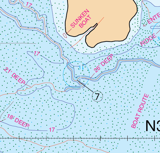
Much of this area is very hard to navigate and places like this are really worth the time and effort to fish for the lunker of a lifetime. At this extreme “S” bend, the creek seems to create a dog leg effect in here. The creek is about 26 feet deep, with a good 15 – 17 feet of water depth surrounding it. A lot of times those fish will hang around the tops of these trees in here. Fish a jig, a Carolina rig, or Texas rig all around the creek channel.
Timing. Year round.
What to do: Use a jig, a Carolina rig, or Texas rig all around the creek channel.
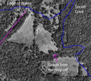
Secret Cove
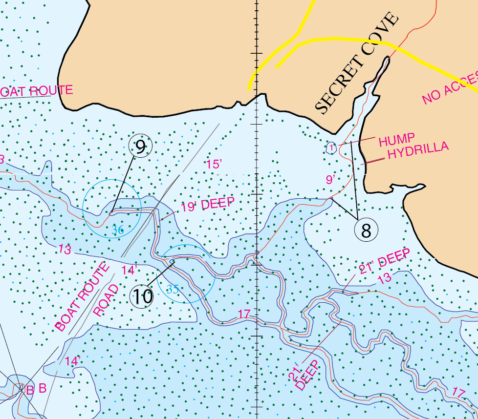
If you’re coming up the big water you will be running up to shotgun Crossing and at that point you will need to turn northeast. When you do turn down this route you need to be very careful because it is not stump free. Some people run it but it’s probably not a good idea. This will take you right to Secret Cove. Secret Cove is a small cut that is well protected for spawning bass. Some call this area Little Fish Hole. This is one of the first places in the first of the year that you will want to use a red rattle trap on. Grass grows out here and you have that creek that comes out of Secret Cove and it dumps off where this timberline is. You can graph the end of this where the creek drops off. It’s a neat area and a lot of close friends will fish this religiously with a red rattle trap in February and catch 8 to 10 pound fish in here. They come off of this area right here at location #8. This is a great, great February red rattle trap pattern.
Timing: Location #8, February.
What to do: Use a red rattle trap between the two coordinates provided.
Timing: Other times of the year.
What to do: Use a Bass Assassin, buzz-bait, spinner-bait, or jig.
Locations: #9 & 10 are locations that GPS coordinates are provided.
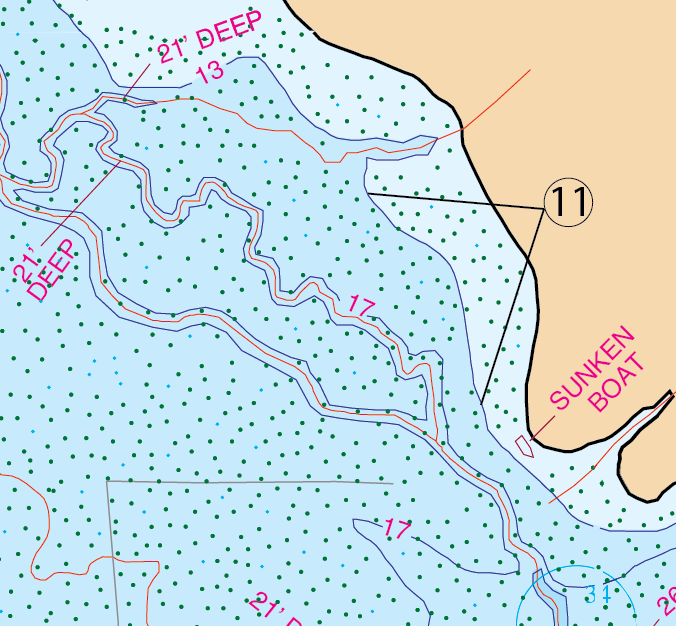
Pull Point
Pull point is the place that is noted on the map as having a sunken boat on it. Over on the west side of this point is one of the last places that the spawn takes place on Lake Fork(location #11). It’s very surprising the fact that you can catch big fish up in Secret Cove on a rattle trap up in February and then come in here at location #11 on income tax day April 15th and catch these fish “Stumping”. For Stumping in here use a large Pumpkin Seed or Watermelon Hawg Craw (the 5″ size). The thing is, there are a lot of stumps and trees in here. Try to find two of the bigger stumps that are close together and then, you flip that Hawg Craw just past it in-between the two stumps. That’s what “Stumping” is. There is one situation down on the Dale Creek hump that is similar to this. Fish in the 8 1/2 pound weight class have been caught here year after year in and about income tax time. It’s a short window of opportunity (about a two weeks) that this happens here. Start checking the fish in here the first week of April. The area between the two coordinates provided is where this is available. It’s a dependable pattern.
Timing: April – two week window. Start checking the first week of April
What to do: Use a large Pumpkin Seed or Watermelon Hawg Craw (the 5″ size)-Stumping technique.
GPS COORDINATES*
1. N32d 55.476′,W95d 41.249′, N32d 55′ 28.537″, W95d 41′ 14.917″CREEK CHANNEL
2. N32d 55.432′,W95d 41.245′, N32d 55′ 25.906″, W95d 41′ 14.698″ CREEK
N32d 55.365′,W95d 41.203′, N32d 55′ 21.889″, W95d 41′ 12.164″ CREEK
3. N32d 55.326′,W95d 41.159′, N32d 55′ 19.536″, W95d 41′ 9.510″ RIDGE
4. N32d 55.175′,W95d 40.843′, N32d 55′ 10.497″, W95d 40′ 50.609″ ISLAND
5. N32d 55.261′,W95d 40.683′, N32d 55′ 15.665″, W95d 40′ 40.970″ HUMP
6. N32d 55.154′,W95d 40.751′, N32d 55′ 9.210″, W95d 40′ 45.033″ HUMP
7. N32d 55.183′,W95d 41.486′, N32d 55′ 10.982″, W95d 41′ 29.173″ CREEK BEND
8. . N32d 55.773′,W95d 41.856′, N32d 55′ 46.408″, W95d 41′ 51.337″ CREEK CHANNEL
N32d 55.694′,W95d 41.881′, N32d 55′ 41.630″, W95d 41′ 52.876″ CREEK CHANNEL
9. N32d 55.671′,W95d 42.245′, N32d 55′ 40.261″, W95d 42′ 14.681″ CREEK BEND
10. N32d 56.607′,W95d 42.155′, N32d 56′ 36.438″, W95d 42′ 9.289″ CREEK BEND
11. N32d 55.450′,W95d 41.594′, N32d 55′ 26.989″, W95d 41′ 35.613″ STUMPIN PLACE
N32d 55.342′,W95d 41.563′, N32d 55′ 20.499″, W95d 41′ 33.776″ STUMPIN PLACE
*Note: These are approximate locations and have not been field checked. The Datum used was NAD 27. These coordinates have been taken directly from our map so they are not entirely accurate. We plan to update these in the future with actual field measurements and we will indicate that when we do. If you have any coordinates that you feel are more accurate and would like to share them, then we would love to hear from you. Also you will notice the above coordinates are in two different formats. The first set is for the older units that showed degrees, minutes.decimal, and the second set is for the newer units that show degrees, minutes and seconds.decimal.