LEARN THE LAKE SERIES
MOUTH OF CHANEY BRANCHWANT TO SEE WHAT IT LOOKS LIKE NOW? – CLICK FOR CURRENT GOOGLE AERIAL PHOTO AND BUSINESS INFORMATION
Chain Saw off of Chaney Point
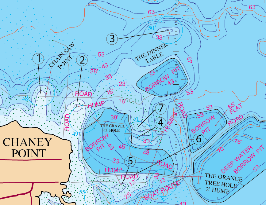
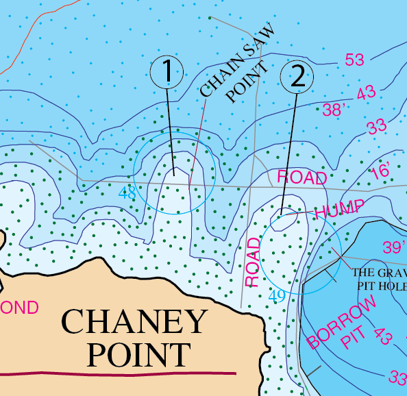
Location #1 & #2Chainsaw and east to the Brooder Pond at the Mouth of Chaney Branch
Northwest of the dam and north of Chaney Point is a place called Chainsaw. If you look down the shoreline you can see why they call this area chainsaw. It got that name because there is a lot of timber in here. There is also a lot of timber off the shoreline in the deeper water as well. Looking at the shore, the shoreline itself does not look all that impressive. Now you have a few boat docks in here and some of the timber has been cut out to allow for that. In most cases the shoreline will give you clues as to how the below water topography might slope. Here, the bank provides minimal clues because the shoreline is uneventful. You can tell it’s a stumpy area but you really can’t tell much more than that about it. However, things change drastically underwater away from the shoreline. What’s hidden below the surface is two very long, extended points that lead out to an old logging area that was once used by a lumber company. Between these two points lies a gut that follows out into the main lake body. If your boat is situated right between locations #1 & #2 and you’re facing the shoreline (looking south), then the roadbed that comes out from the shore and out into the deep water will be on your left. At some point (about 700 feet from the shoreline), out in the deep water, there is an intersection where the road splits off to the left and to the right (east or west). That roadbed ends up crossing the ends of both points-locations #1 & #2. So what you have is two off shore locations that consist of some gnarly, irregular humps, and points with stumps, roads, and lay down timber all around it . Here is where that pay-off is located. The good thing is that a lot of people catch a lot of good fish off of Chainsaw. The Chaney Point area is a good all year round place to be and is also a great place to night fish. Combine all that with the fact that the area has close proximity to good spawning shallows and the main Chaney Branch creek channel. That is why this place turns out to be a good all round structure that falls right along the north mouth of the main body of this branch.
Just off of that #2 location on the map you will see a reference to the “Gravel Pit Hole” and it points to the east side of the location #2 hump where the water begins to deepen. If you look at the map you will see that drop-off area east of location #2 also has a road bed that runs down along the east side of it. This location is in the back end part of this protected bay area. It’s in about 33 feet of water. It’s a big pit and in the east end of this thing it gets as deep as 48 feet. So, if you sat on top of location #2 and drove your boat due east and watched your graph, you would be on top of it when the depth started severely dropping off . Once you have found that edge you could graph that whole drop-off from north to south until you located the fish. This location is good in May and June and then good again in October and November. My old friend Kerry Stafford used to fish this hole back when he and I were working on the original fishing map. It’s a decent summer and winter time hole (and probably a good crappie hole as well).
Timing: April – location #1, #2 and all the way back toward the bank and west to the pond.
What to Do: Usually in April you can have luck to some extent by using a top water bait such as a long A. Sometimes you’ll hang a fish that you are unable to turn around in this area. This hump and point is also home to some good fishing on Carolina rigs. Also keep in mind that since you have a lot of stumps in this area a smart, big fish can sometimes free itself by wrapping around one of those stumps. Naturally you don’t want to horse him out of there however you don’t want to spend any more time than you have to getting him to the surface either. Expect several fish in here around this time of year using these baits. Use what you feel comfortable with in here and use different techniques till you figure out what’s working best for the time of year that you do fish this place. Just be patient when you come in here because big bass are often caught in this area.
Location: #2-Gravel Pit Hole – East side of that #2 hump in 33 feet of water
Timing: May/June, and October/November
What to do: Flutter Spoons, football jigs, big fish swim baits, and Carolina Rigs.
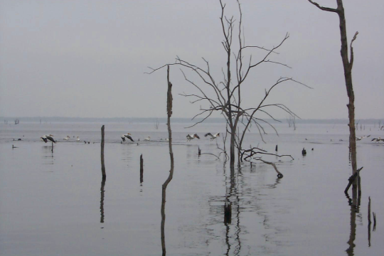
 Chaney Creek is one of the top nine creeks on Lake Fork. This creek is full of trees as you can easily tell by the photo above. This creek has a tendency to produce more double-digit fish than any other creek.
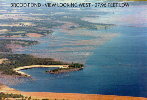
The Brooder Pond Area
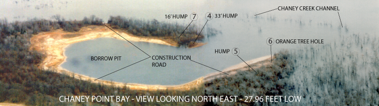
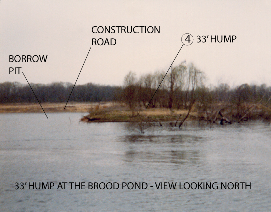
The Brooder Pond is located east of Chainsaw. All of this is located on the end of Chaney Point. The Brooder Pond’s name gives it’s purpose away, as it was part of the original stocking program by the Texas Parks and Wildlife. This area was also the site where the Reservoir Builder removed dirt from the bottom of the future lake bottom for use in the construction of the various needed roads, the dam and the emergency spillway. So the large pond-like area is what engineering would call a “borrow pit”. Removing the dirt as they did near the future shoreline, created a bay like structure in here and therefore some people call the south shore of this borrow pit area “Chaney Point Bay”. There are several of these borrow pits located in this area of the lake. It only makes sense that they would take dirt out for the dam as close as they could to the dam in order to reduce construction dirt hauling costs. I have seen this happen on several lakes so the practice is fairly common.
The Brooder Pond has a vast diversity of humps and drop-offs into some of the deepest water located on Lake Fork. As a result of the stocking fish being originally hatched here in this location it seems to have created a home for future generations of hatching s to strategically relate to. As a result, the brooder pond (or gravel pit) will still hold these grown fish on the humps. Now that the lake has engulfed this bay it continues to serve some measure of protection for the available bait and large bass that come from the deeper depths of the lake. This area profits greatly from the variety of depths available. You will find depths in the range of 16 feet deep to 33 feet and as deep as 76 feet deep in the largest of the borrow pits. The Brooder Pond area has timber on the parts that were not excavated. Take note of that and be careful if you’re driving your boat through here. Some of the stumps are visible and others are just below the surface. Going fast through here might be a big mistake.
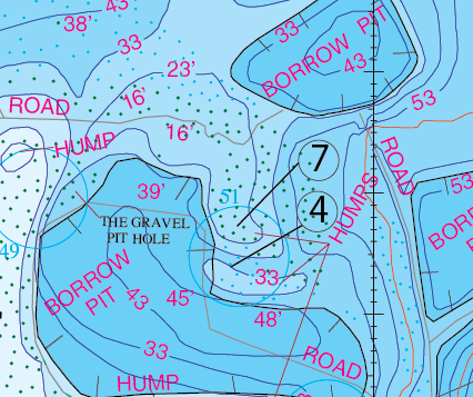
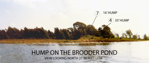
Location: #4 
You will notice that location #7 is shown near the 23 foot contour line on the inset map. This is the hump that comes up to about 16 foot deep. Just south of there, and divided by a drop-off is another small hump (location #4) in about 33 feet of water.
What to do:
OK, these numerous borrow pits are a solid lead into the main body of Chaney Branch and they contain shallower water running between them on the main lake side. The overall site has a good, gradual drop with some irregular contours. This area has a lot of good things going for it. The bass follow the break-lines up to shallower areas in order to more easily isolate bait fish when they feed. The main idea when in here is to fish these break-lines all year long. This also continues to be a good night fishing area and big bass are caught in here. If it’s spawn time in here you throw the usual Hot Pink or Bubble gum Texas Rigged Lizzard or a white Texas Rigged lizard with a yellow Dip and Glo tail. If you’re not in spawn mode then it’s your favorite jig, lizard, or big fish swim bait.
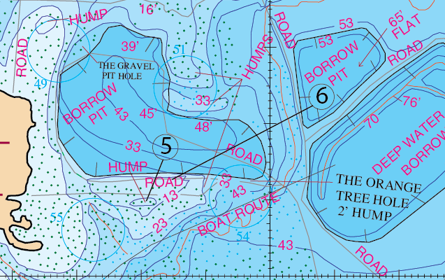
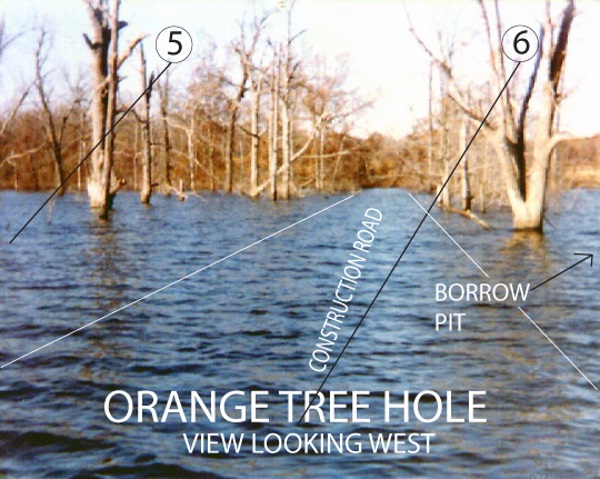
Location: #5 & #6
Located along that south part of this bay lies a construction road that circles this borrow pit. The road runs along the high bank south side of the pit , turns due east, and then protrudes out to cross the main Chaney Branch creek channel. In this road’s trek it passes locations #5 & #6. Location#6 is what guides sometimes refer to as the “Orange Tree Hole” and is just a hole located near the 13 foot contour. It’s a hump that comes up to about 2 feet deep. It is located on the east end of this pit’s road bed right near where the road begins to descend rapidly into the deeper water. So essentially this road slopes drastically down in two different directions. The road slopes to the north down to the pit and it slopes to the east down to the creek. Location #5 is a hump in about 5 to 8 feet of water and it lies just south of that same road bed. This road/tree hole/hump is a good fishing place year round. So all in all, this Chaney Point/Bay/Chainsaw Humps/Brooder Pond/Orange Tree area is a very interesting and structurally intricate area to fish. It’s a good place to spend some time in here learning it.
Timing: The first three weeks in April
What to do:
Remember that Chaney Creek’s spawn time is later than most other creeks. Usually spawning and bedding fish will do so during the first three weeks in April. The north shore of this entire branch is good from one end of it to the other. Use the usual spawn baits like Texas Rigged Lizards in hot pink, or white with Dip and Glo tails. This area is fun during the spawn.
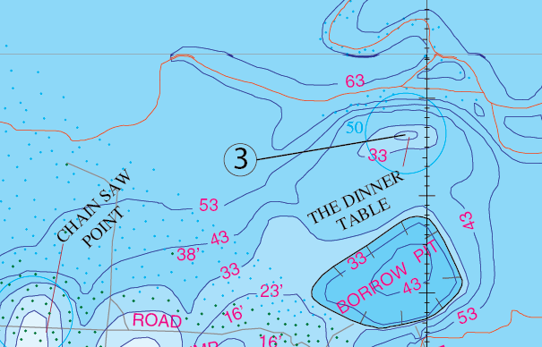
Location: #3
Location #3 is called “The Dinner Table”. It is a shallow hump neighbored by a deep creek on the main lake side, and immediately drops down to 33 feet, and then a little further out it drops down in the 60’s. It’s located out in the main lake area and it’s sort of like that proverbial lone tree in the big pasture that cows will invariably head for. In this case it’s that lone hump out there in the middle of the lake that draws bass in. This area has produced many bass over 10 pounds and is a great night fishing spot. It’s typically good 12 months of the year. For years this site was a super fishing hole. From what I hear the fishing pressure through the years seems to have put a dent in it’s viability. It’s ability to produce good fish is still in tact however just be aware that this legendary location may have slipped a few notches as a result of wear.
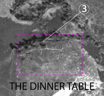
Timing: Crappie in October through February and will also hold bass in October and November.
What to do:
The dinner table (location #3) is a great crappie hole during from October through February and will also hold bass in October and November. For bass you can use deep diving crank baits, flutter spoons, swim baits, and football jigs. A Carolina rig seems to do well with a heavy slip weight. An advantage to using the slip weight is that the bass will have a harder time feeling that weight when it takes your bait and to me it provides the bait more action ability.
GPS COORDINATES*
1. N32D 48.378’ & W95D 33.475’ CHAINSAW POINT
2. N32D 48.329’ & W95D 33.350’ HUMP
3. N32D 48.561’ & W95D 33.022’ THE DINNER TABLE
4. N32D 48.222’ & W95D 33.114’ HUMP
5. N32D 48.098’ & W95D 33.193’ HUMP
6. N32D 48.127’ & W95D 33.133’ ORANGE TREE HOLE
7. N32D 48.268’ & W95D 33.130’ HUMP
*Note: These are approximate locations and have not been field checked. The Datum used was NAD 27.