LEARN THE LAKE SERIES – MIDDLE OF LITTLE CANEY CREEK
Location #1 thru #8WANT TO SEE WHAT IT LOOKS LIKE NOW? – CLICK FOR CURRENT GOOGLE AERIAL PHOTO AND BUSINESS INFORMATION
ASSOCIATED VIDEO LINKS
EPISODE 5. Fishing structures at the middle of Little Caney Creek. This covers locations 1,2,3,6,& 7.
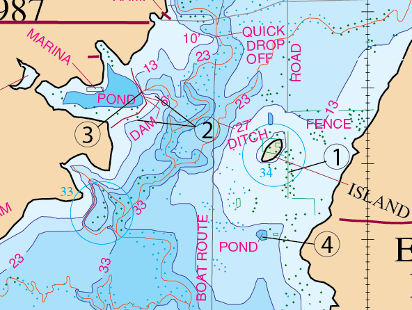
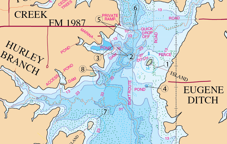
Location: #1
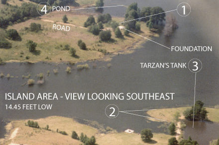
The Quail Hollow RV area and Hideaway Harbor are situated right in this area at the end of Hwy 1987. Actually Qual Hollow its at the north edge of Tarzan’s Tank. Tarzan’s Tank is a very nice pond. Across from this big pond, there is an island with a ditch running off on the back side of the small island. That ditch runs down an old fence row and fairly close to that is a small pond on the south side of the island. This is an excellent spawn area, and will produce huge bass. What most people don’t know is that there is a concrete slab foundation that sits close to the island and most of the time it sits out of the water. If you look at the map, look closely at the 13 foot contour line. This contour line pretty much outlines a very large flat. Now when you get Lilly pads in here they usually start in that northeast corner of that flat where the map it says “Fence”. If you look at the northeast side over there, you will notice that the 13 foot contour runs south, parallel with the bank up until it reaches the island area. Once it gets there, it bows way out into the deeper water, and circles the island. That 13 foot contour line then meets back up with the main shore southeast of the island and continues on fairly parallel with the bank. The inconsistency of this shoreline is what brings the fish in here. It’s just a little bit of variation in the structure that attracts these fish. Now, what happens in here, or should I say, the area that you probably need to key in on is the little ditch back behind the island in here. There is a fence as well with that ditch and you will want to focus on this area (location #1). The combination of the island, the vegetation, the ditch, the fence and the flat all combine together to make this a very good spot.
What to do: Cast a weightless watermelon Bass Assassin with a 5/0 offset shank hook in the hydrilla and let it lay a couple of seconds, then move it forward, and let it sit. When you feel that fish just pop that hook and hang on.
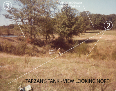
Location: #2
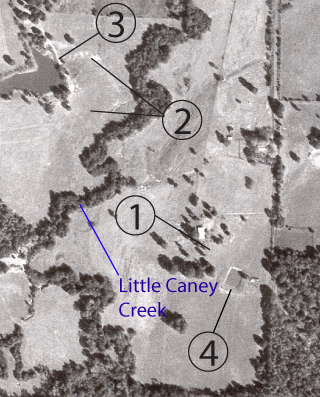
The picture shown below shows David Kelly standing below the dam of Tarzan’s Tank (location #3). This was way before Little Caney had any water in it other than the creek channel. You will notice that there are trees right up on top of the dam. One thing that is special in regard to underwater topography and funnels is the way that the ditch is formed in here. You have a natural funnel with regard to location #2. You have some ditch with quite a lot of undergrowth in here that makes a natural left turn coming from the south and then it runs right up into the base of this really nice pond dam. One very special feature in this is in regard to location #2. #2 is sort of a flat that has a natural horizontal curve to it. The point of it seems to curve in and decline as it comes into the base of that pond. This forms a natural funnel point for these fish. The way this thing is shaped it allows these fish room to spread, feed, and funnel into this underwater point and creek. This area has a lot of potential and it is pretty special as far as bass holding goes.
What to do: Cast a Texas or Carolina Rigged Lizard or worm along the contour of this point.
Location: #3
This top of this Tarzan Tank Dam offers some fine fishing as well as what we previously said about the base area point. There is a 6 ft to 23 ft drop right off the top of this dam and this dam is known to house big concentrations of bass. Right to the north of the pond (location #5) is an underwater extended point next to the FM1987 road that goes all the way across the lake. This is very good to fish, especially with Carolina Rigs, Texas rigs and crankbaits.
What to do: Cast Carolina Rigs, Texas rigs and crank-baits along this pond dam.
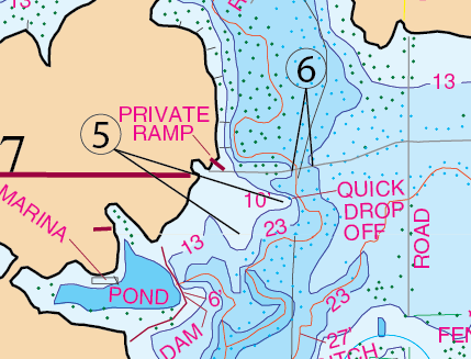
Location: #5
This Hwy 1987 road, the main road coming into Hideaway Harbor, used to go right across where the lake now is. Location #5 is two long extended points that show due south of the west bank where that Hwy 1987 came through. Now this is just north of that Tarzan’s Tank pond. These two points have good drop off. This will drop from 10 foot deep to 23 feet. These two points are good to fish especially with Carolina Rigs, Texas rigs and crankbaits.
What to do: Throw a Carolina Rigs, Texas rigs and crank-baits.
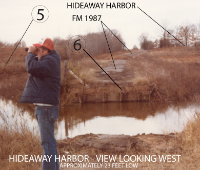
Location: #6
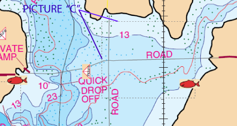
At one time there was a bridge right where Hwy 1987 crosses Little Caney Creek. This bridge allowed access to the other side of that small creek channel. At some point during the construction of the reservoir, the bridge was removed. The picture shown below, was taken back in the old, old days. The creek in the picture is the original Little Caney Creek (back then they may not have even had a name for it). The road shown in the picture (directly center) is the old FM 1987. Hideaway Harbor will eventually sit at the top of the hill on the right. One key thing to notice here, is that part of the old bridge shoring is still in tact. You can spot it there at the end of the road. You will notice that taking out the old bridge and leaving the shoring makes for a very nice drop off (location #6). Now that the bridge is gone, this is now an abrupt fall off into the creek channel. This is a great place to throw a Carolina Rig or a Fluke. You can imagine that you would want to just thrown that bait up on the road and pull it off the ledge and let it gently settle down to the bottom there. I can imagine that often when you pull it off that ledge that bait never makes it to the bottom with out having a good fish on it. It appears that both sides of that channel, still have the shoring in tackt, so you have another side similar to the west one on the east bank as well. This is one of the spots that you’ll want to spend a little time throwing at it.
What to do: Throw a Carolina or Texas Rigged Lizard or a Fluke. Pull it off the road into the channel and let it float down.
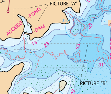
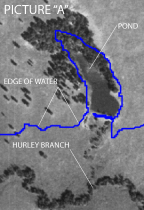
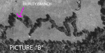
Interesting picture of the bottom of the lake. Dashed line in map below shows location of picture. 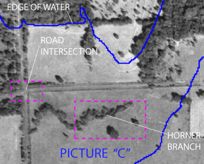
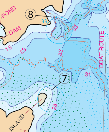
Location: #7
This island #7 is fished by the guides quite a lot. These folks bring clients in here and when they do they use Carolina Rigs, Jigs and that sort of baits in here. they get up around this island and they fish off the edge of this point (Location #7). The point contains an abrupt change of depth in here and it is a real popular spot however, in actuality, it’s probably not quite as good as the dam on Tarzan’s Tank.
Location: #8
Funnel Point.
Interesting pictures of the lake bottom
GPS COORDINATES*
1. N32d 51.410′,W95d 33.125′, N32d 51′ 24.581″, W95d 33′ 7.505″ GUT
2. N32d 51.492′,W95d 33.328′, N32d 51′ 29.522″, W95d 33′ 19.671″ POINT
2a. N32d 51.472′,W95d 33.335′, N32d 51′ 28.300″, W95d 33′ 20.108″ POINT
3. N32d 51.495′,W95d 33.352′, N32d 51′ 29.714″, W95d 33′ 21.146″ POND DAM
4. N32d 51.300′,W95d 33.157′, N32d 51′ 18.000″, W95d 33′ 9.448″ POND DAM
5. N32d 51.563′,W95d 33.241′, N32d 51′ 33.798″, W95d 33′ 14.435″ EXTENDED POINT
5a. N32d 51.523′,W95d 33.295′, N32d 51′ 31.409″, W95d 33′ 17.673″ EXTENDED POINT
6. N32d 51.590′,W95d 33.240′, N32d 51′ 35.390″, W95d 33′ 14.422″ DROP OFF
6a. N32d 51.593′,W95d 33.219′, N32d 51′ 35.585″, W95d 33′ 13.168″ DROP OFF
7. N32d 51.151′,W95d 33.443′, N32d 51′ 9.067″, W95d 33′ 26.609″ POINT
8. N32d 51.347′,W95d 33.428′, N32d 51′ 20.836″, W95d 33′ 25.709″ GUT
*Note: These are approximate locations and have not been field checked. The Datum used was NAD 27. These coordinates have been taken directly from our map so they are not entirely accurate. We plan to update these in the future with actual field measurements and we will indicate that when we do. If you have any coordinates that you feel are more accurate and would like to share them, then we would love to hear from you. Also you will notice the above coordinates are in two different formats. The first set is for the older units that showed degrees, minutes.decimal, and the second set is for the newer units that show degrees, minutes and seconds.decimal.