This is a video clip taken from a film made of Lake Fork back in 1988. This view is looking north. Area initially shows the Boot Hill area and follows along the west bank, passes Boot Hill cove area and ends at the cove at Lake Fork Marina. In the background can be seen the West 515 Bridge. The video was taken approximately 3 years after the lake fully filled with water. Video provided by Robert E and Michele Wood with S-W Group Inc. – Photo Fishing System Company. COPYRIGHT 1988 ALL RIGHTS RESERVED.
Horseshoe Ridge
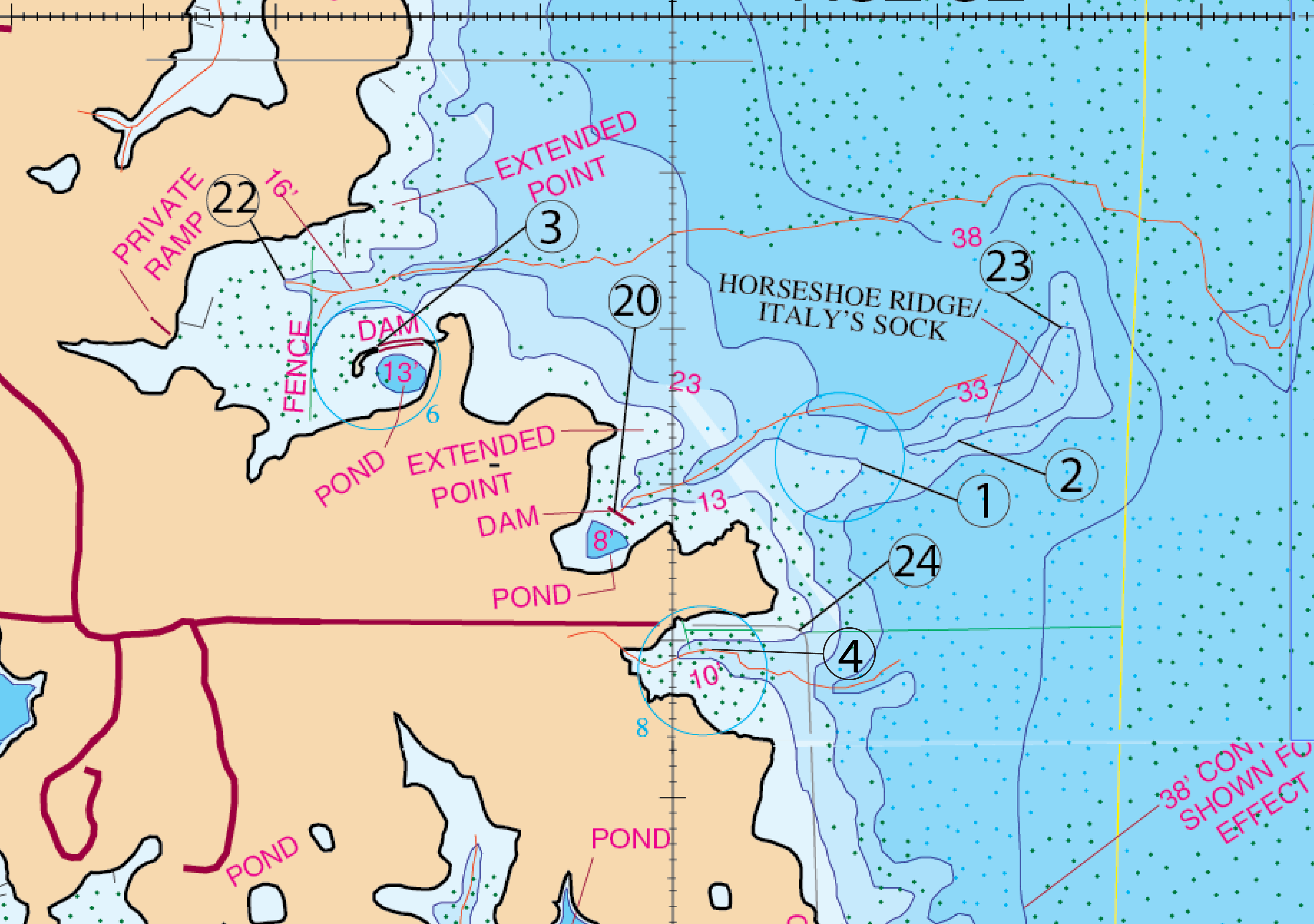
Locaations #1, #2, #3, #4, #20, #22, #23, & #24aka Italy’s Sock or Boot Hill
WANT TO SEE WHAT IT LOOKS LIKE NOW? – CLICK FOR CURRENT GOOGLE AERIAL PHOTO AND BUSINESS INFORMATION
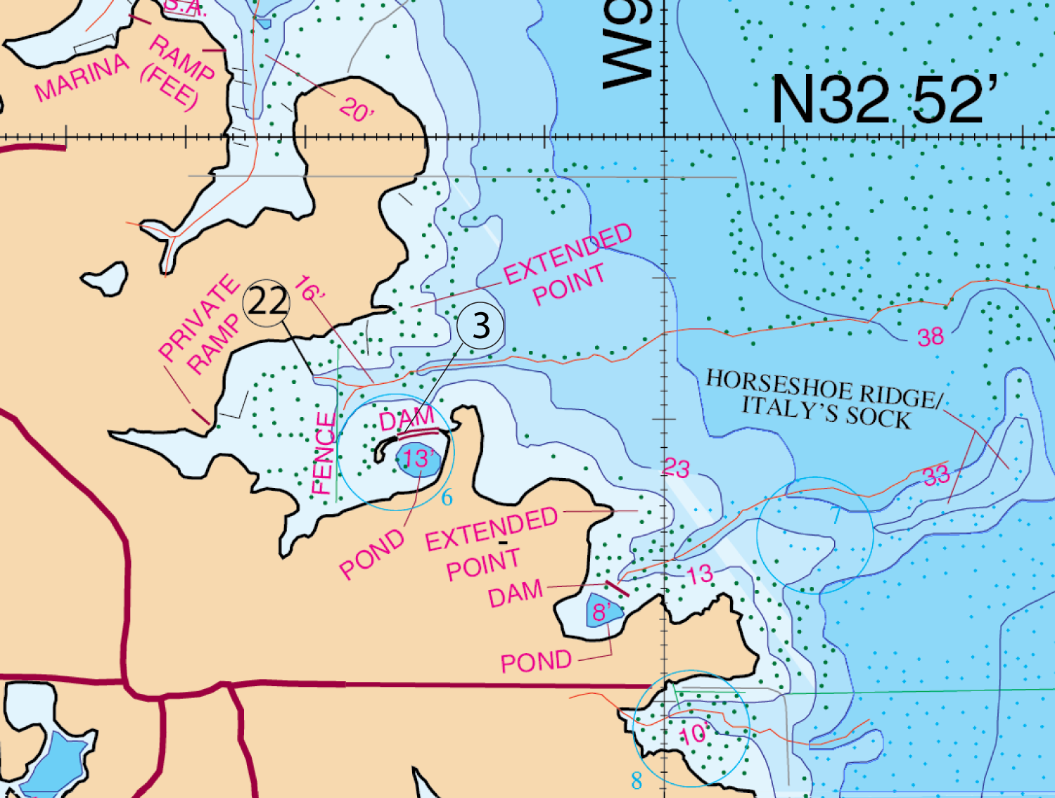
Location #22 & #3
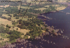
Location: #22
The Cove Due North of Horse Shoe Ridge
The cove just north of Horseshoe Ridge is a good spawning area. It has a lot of structure value in there. If you will notice it has a funnel point that also has a creek running through the center of it. When you get into this cove you will find some very fish-able boat houses on the north shore that you may want to check around. On the south side you will find an irregularity of a pond with a dam. Also you will see a fence that T-bones the creek and runs from the south end of the cove south to north side. This fence and creek is always a natural route for these bass to traverse along in and out of the cove. It’s a key part of this cove because it is their main enter and exit highway before, during, and after the spawn takes place in this cove. If you were going to fish here you would prefer that it be during a spawn situation. Find where the creek crosses the fence. Pay particular attention to the north shoreline because the fence becomes a natural route for these fish. Concentrate on the north shoreline for these spawning fish. The only way you would stay off of that site is when it is too windy. The first choice of baits would be a 1/2 oz. Black/blue jig, Carolina rigged Lizard Black/blue, a chartreuse/white 1/2 oz. willow bladed spinner bait-slow rolled. You would need to position yourself parallel with the fence that points toward the north shore. A watermelon super fluke with a chartreuse dye dipped tail would work as well. If your water temperature is right at or near at 52 degrees a good bait choice would be a red rattletrap. If your water temperature reaches 55 degrees your normal choice would be the white/chartreuse willow bladed spinner bait or a suspended rouge(black back, gold sides and orange belly.) When finding a big fish on it’s bed you’ll want to throw a 6 inch Gene Larew Hog Craw (Texas Rigged) into the bed. If the water is cloudy or stained you’ll want to go to a six or eight inch white lizard dipped in yellow worm dip (Spike it Dip and Glo). If you can easily see the beds then you can go with the standard bubble gum colored lizard (same sizes) with the small head weight.
Timing: The spawn
What to Do: Use a 1/2 oz. Black/blue jig, Carolina rigged Lizard Black/blue, a chartreuse/white 1/2 oz. willow bladed spinner bait-slow rolled. A watermelon super fluke with a chartreuse dye dipped tail would work as well. If your water is at 52 degrees a good bait choice would be a red rattletrap. If your water temperature reaches 55 degrees your normal choice would be the white/chartreuse willow bladed spinner bait or a suspended rouge(black back, gold sides and orange belly.) When finding a big fish on it’s bed you’ll want to throw a 6 inch Gene Larew Hog Craw (Texas Rigged) into the bed. If the water is cloudy or stained you’ll want to go to a six or eight inch white lizard dipped in yellow worm dip (Spike it Dip and Glo). If you can easily see the beds then you can go with the standard bubble gum colored lizard (same sizes) with the small head weight.
Location: #3
The other part of this strategy is that you cannot get out of this cove without fishing the dam area to the south. You will want to hit the west side of the pond and also to the point area to the east of the pond, and all the way around the point to the cove south. This point, represents a decent lake point leading directly into a good, main lake spawning cove. Points like this can often, at times, be a key place. So, if you’re around this point somewhere close to the first part of March, you may want to see what you can pull off of it. Around that same point, the cove mentioned previously south of there, is a small cut in the bank that fish do spawn in. Just keep your eyes open for a possible big fish on a bed. If you do see a good fish in there, a good choice to use is a 6″ Gene Larew Hog Craw, Texas rigged lure, as well as a standard bubble gum colored lizard. This will will work well. Once you have completed this, then you’ve pretty much covered the entire area and you can move on. Also, it’s probably noteworthy to know that the back of this cove is really not all that great because it is too shallow and it is too far away from deep-water access. The picture shown below shows the Pond that lies in the cove for Location #3. Lake level elevation 388.25′. 14.45′ below normal pool level.
Timing: First part of March, and all seasons first and last hour of the day.
What to do: Use is a 6″ Gene Larew Hog Craw, Texas rigged lure, as well as a standard bubble gum colored lizard. Also you will want to fish the first and last hour of the day if you’re in this vicinity during times other than spawn.
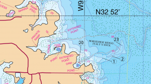
LOCATION #1, #2, #20 & #23
Location: #1, #2, #20, & #23
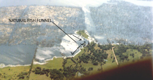
Italy’s Sock (also known as Boot Hill or Horseshoe Ridge) – Italy’s Sock was even good back in the old days when the hump of it used to stick up out of the water. You could throw a jerk-bait around it and catch seven and a half-pound fish. Today Italy’s Sock a.k.a. Boot Hill or Horseshoe Ridge- is a prime area for double-digit fish. The area from its pond/dam #20 and to the very East End of Horseshoe Ridge #23 is a classic funnel point. You have points, ditches and funnel points that provide you the chance to catch a huge fish. You hear the word “funnel point” spoken often. It’s a catch word that people in the fishing industry probably tend to over use. It’s a word used to simplify something that is fairly detailed in actual practice. Sometimes the real meaning of that word is overlooked and is cloudy to some people. It really requires more than one word for an explanation. Some anglers don’t totally understand why it is called a funnel nor can they recognize the topographic features that would indicate that they were looking at one. I was talking to a friend of mine last night and he put it in words that most people, even I could easily understand. Basically he said it could be explained with an old time chicken joke. Why did the chicken cross the road? He said that but he substituted the word “fish” for chicken. Why did the fish cross the road? Well, his answer was that it really didn’t cross the road. Normally it would not cross the road so the chances are that you wouldn’t find him in the middle of the road. Right, it didn’t cross the road because that ain’t his thing. This is your typical lazy fish that does not want to spend the extra effort in order to do that. It’s just like any other creature. When you go to the mail box out in front of your house, you don’t head for the back door and then climb over the top of your house in order to get to the mailbox at the street out front. That would cause you some significant physical discomfort. Also, in the process of climbing over the roof of your house you might fall off and hurt yourself. That would be a safety issue. A big bass thinks in terms of limited effort exerted and safety. For one, this big bass has this thing called an air bladder. This air bladder keeps it from sinking to the bottom. So, whenever these fish move up or down in the water (when they make a significant change in elevation), this badder is affected and it requires the fish to expend an amount of energy which in turn results in some amount of discomfort. So, like every other creature in the world, this fish finds that if it follows a path of least resistance it can expend less energy and have less to worry about. And besides that, their food (bait fish) is taking that same path of least resistance for the same reasons. Staying along that same comfort route provides these fish more safety. So, for folks to sum up all that information into the one word “funnel” is convenient only. It could be more helpful if people talked more about it, especially for those that have never really had someone explain it in simple terms. That would be me. I like things to be simple. So, Boot Hill provides the perfect example for the perfect, natural, funnel point of any lake. If you can study and totally recognize this topographic feature, then that pattern can be applied to any lake. If you will notice, there is a significant drop-off on both sides of this nice, long extended, main lake point. A point like this can often contain fish in different levels along that same path.
Jimmy Martin-mapping the far west side of Cooper Lake when it had just opened – summer of 1998
That being said Boot Hill is a much more versatile location than the cove due north of it. The cove north of it is limited mostly to spawn related type fishing. The “Hill” area provides most everything you will need to fish all types of patterns through out the year. It contains migration routes, summer patterns, spawning patterns, feeding patterns and etc, etc. All these patterns are very available in the Boot Hill area. For the super-big double-digit fish in the area you can bet that they will follow that before mentioned funnel directly into the dam of Boot Hill’s pond #20. This thing comes way out into the main body of the lake. You will notice lots of trees that were left out there when they filled the lake as well. The large fish will feed in the vicinity of these broken off trees/stumps. These fish will travel a path back and forth along both sides from the tip of Boot Hill, back west and back east along that route. At the dam of that pond (location #20) you will want to fish the first and last hour of the day if you’re in this vicinity. You can usually pick fish up there during those two moments. This is more of a feeding pattern that occurs here. Obviously feeding patterns are different than the spawning patterns talked about previously.
Timing: May
What to do: Use flukes, football jigs, deep diving crank baits, trick worms and etc.
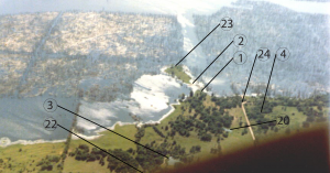
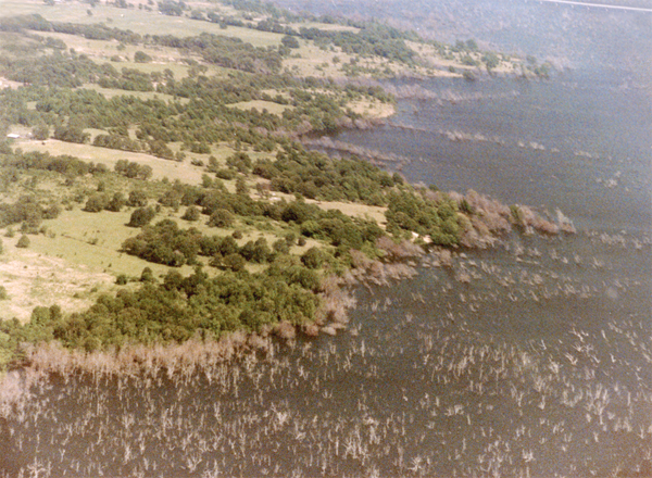
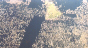
The topography here (the elevation and shape changes to this area) creates a natural “fish” funneling effect (shown in the picture below). This is Boot Hill shown below. You are looking at a view looking east. Now, looking at this picture realize that these fish are going to follow back and forth up and around this point protruding into the lake. Now think of adding another 28 feet of water over the top of all this. Those fish are still going to be doing the same thing now as they were when all that water wasn’t covering it. They’re not going to be climbing over the top of their house. They are going to be following a path around this structure. That is a big bass doorway. That bass door is the same equal thing to him as the front door of your house is to you.
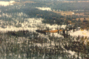
Below is that same tip of Boot Hill. You’re looking looking West. You can easily see the vast amount of timber that is close by.
Here is a shot of Boot Hill looking South at it 28 feet below normal pool level. It’s a significant hump for a fish to have to climb over so they’re going to stay along the contour of the this structure. Now what you need to do next is let your graph show you where and at what depth the fish are holding at along this route. That will tell you where to work that path.
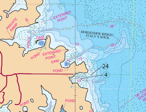
LOCATION #4 & #24
Another thing to remember about Boot Hill is the area to the south of it. The area south all the way to the underwater road (#24) in about ten to twelve feet of water is the area and depth this refers to. This is good right around Labor Day. Show up about 5 o’clock in the afternoon and you can usually bet that the fish will more than likely be feeding there. You may even see them actually break the surface of the water. They can be caught with rattletrap lures, spoons and etc. When you run upon bass when they fall into a feeding frenzy like this, it is always a pleasure to experience. The first outing that I took my kids on we ran into this very thing. They were pulling one bass in right after another. They really enjoyed that first trip. From then on they thought it would always be like that. It was a really hard act to follow. Labor day is close to the first of September. Just keep this in mind if you’re in the area around that time.
Timing: Labor Day – First part of September
What to Do: rattletrap lures, spoons and etc.
GPS COORDINATES*
1. N32D 51.710’ & W95D 36.868’ EXTENDED POINT
2. N32D 51.733’ & W95D 36.779’ HORSESHOE RIDGE
3. N32D 51.790’ & W95D 37.212’ POND DAM
4. N32D 51.590’ & W95D 36.995’
20. N32D 51.670’ & W95D 37.045’ POND DAM
22. N32D 51.830’ & W95D 37.290’ SPAWNING AREA
23. N32D 51.798’ & W95D 36.705’ END OF HORSESHOE RIDGE
24. N32D 51.608’ & W95D 36.908’ ROAD BED
*Note: These are approximate locations and have not been field checked. The Datum used was NAD 27. These coordinates have been taken directly from our map so they are not entirely accurate. We plan to update these in the future with actual field measurements and we will indicate that when we do. If you have any coordinates that you feel are more accurate and would like to share them, then we would love to hear from you. Also you will notice the above coordinates are in two different formats. The first set is for the older units that showed degrees, minutes.decimal, and the second set is for the newer units that show degrees, minutes and seconds.decimal. (Second set not available at this time. They will be calculated at a later time).